Marc's Public Blog - Biking, Running, Rollerblading and other Exercising


All | Aquariums | Arduino | Btrfs | Cars | Cats | Clubbing | Computers | Dining | Diving | Electronics | Exercising | Festivals | Flying | Halloween | Hiking | Linux | Linuxha | Monuments | Museums | Outings | Public | Rc | Sciencemuseums | Solar | Tfsf | Trips


Table of Content for exercising:

More pages: March 2023 September 2022 February 2022 January 2022 October 2020 August 2020 May 2020 April 2020 February 2020 July 2015 February 2013 July 2012 February 2012 June 2011 May 2011 July 2010 April 2010 December 2009 November 2009 May 2009 April 2009 March 2009 September 2008 June 2008 May 2008 January 2008 October 2007 September 2007 June 2007 May 2007 April 2007 March 2007 February 2007 August 2006 July 2006 June 2006 March 2006 September 2004 August 2004 May 2004 April 2004 March 2004


2023/03/30 Quick Bike Ride on Steven's Creek Trail AFter Heavy Rains
π 2023-03-30 01:01 in Exercising

some paths were still under water


lots of PG&E trucks and even boat to try and maintain the lines

strangely the bay level was low at that time


Would have been fun to complete a loop but the PG&E access paths were not open to the public

2022/09/22 Fremont Older Through Garrods Farm
π 2022-09-22 01:01 in Exercising
It had been a while since I went biking. I took my road bike which was a big mistake and tricky once I got to the dirt. I had to walk some bits because my tires were too narrow and didn't have enough grip, but still had a good time:


2022/02/06 Impromptu Bike Ride to Baylands/PAO
π 2022-02-06 01:01 in Exercising
Original goal was to try out the bike on a short ride. end result was a 28 mile ride, haha. Weather was beautiful for early february:

trees were blooming already, and had no idea that winter wasn't over

new google campus is ready


the bird center was closed unfortunately


been a while since I flew out of PAO

nice shot with 3 arriving planes


shoreline lake was beautiful


2022/01/26 Sunset Hike to Black Mountain
π 2022-01-26 01:01 in Exercising
I drove to the top of Montebello for nice views and a sunset hike to Black Mountain:


Sure, you can also bike up (and it's a tough ride), but it's a fairly long bike ride back in the dark, so driving was easier.

Beautiful hike with sunset views, we'll have to do it again.

See more images for Sunset Hike to Black Mountain
2020/10/14 Biking Los Altos Hills
π 2020-10-14 01:01 in Exercising
Jennifer and I went for a bike ride that was a bit more involved, this time the lock we went to discover was far Los Altos Hills between the freeway and the hills. Lots of up and downs... (actually my GPS said we only did 24 miles in 7h, but we went up 3000ft)

We started by Rancho San Antonio:


a bunch of few turkeys

looking for prey
looking for prey

nice colors
nice colors


The hills are hilly, lots of up biking (or walking), with views:


For reasons unknown, we found petrified trees on the side of the road:


More nice views:


Once we got to the top of Olive Tree Lane, where I thought from the map, we could connect to Chamise Trail, but no, the residents put a gate to stop people from going to a public road to a public trail. I had to find a pretty painful way around the fence, through the brush:


took 15mn to get around

this doesn't show how filled with dirt and leaves, I got

We then exited the park towards Los Altos Hills and a nice little private lake they don't like to share with others :)


More houses:


rich kids get their own private playground

deer in your backyard (both good and bad)

you can camp in your own yard

toy car
toy car


Another connecting path:


nice view of the private lake


we then took another connecting path to another path along 280, and back out to civilization

See more images for Biking Los Altos Hills
2020/08/25 Sunset Biking to Black Mountain During Great Redwood Fires on a Clear Day
π 2020-08-25 01:01 in Exercising
After the terrible amount of smoke we had 2 days prior, I went back in the evening when the wind had shifted and the smoke was going in other directions. What a difference. It went from a PM2.5 of over a 1000 (do not breathe) to just 10:


I had to hurry to get enough light before losing it

smoke was visible but on the east side of the bay


black mountain peak was clear

clear at the top
clear at the top

A few animals were out:


The ocean side of the view was nice too:

smoke means nice views


It was then time to bike back since I didn't have a bike light:


Soo much nicer than 2 days prior...

2020/08/23 Biking to Black Mountain During Great Redwood Fires
π 2020-08-23 01:01 in Exercising
I was curious to see layer of smoke and maybe more by going higher (about 3000ft), so I drove up montebello road and then biked the rest to Black Mountain. The 10mn worth of biking was quite hard, I couldn't breathe well with my N99 mask and I really needed it given how terrible the air was (more than 5 times worse than lower down at home).

the bike barely fit
the bike barely fit

not the best view
not the best view

top of montebello
top of montebello

oops, good thing I had my N99 mask

I unpacked my bike and did the short ride to the first radio tower and then black mountain. I was very out of breath breathing with that max (and even the filtered air not being prefect probably):


couldn't really see the bay

and that's why
and that's why

biking back to my car


And then I went down, and the air was definitely better:


2020/05/31 Urban Explorers
π 2020-05-31 01:01 in Exercising
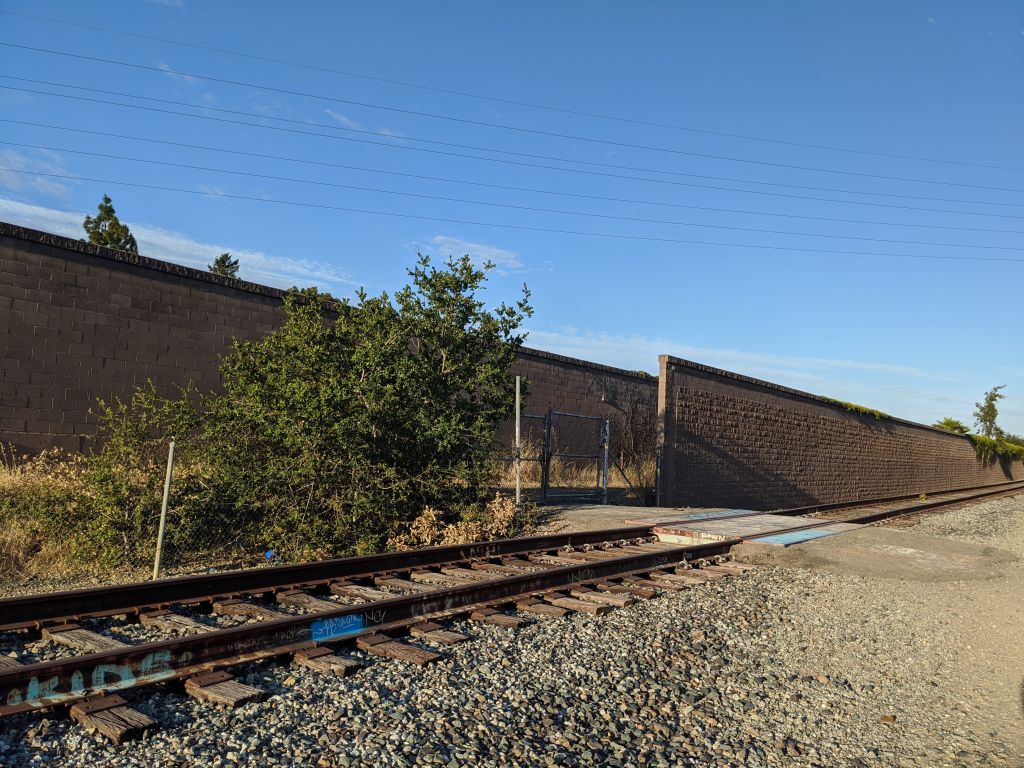
Interesting walk under a secret tunnel under 280 just minutes walk form our house, a railroad crossing to nowhere, a secret BMX riding park and doors in the freeway wall with chairs to watch the traffic go by.

Map: https://connect.garmin.com/modern/activity/5023804251

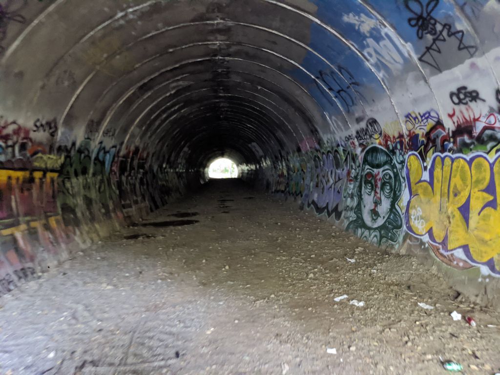
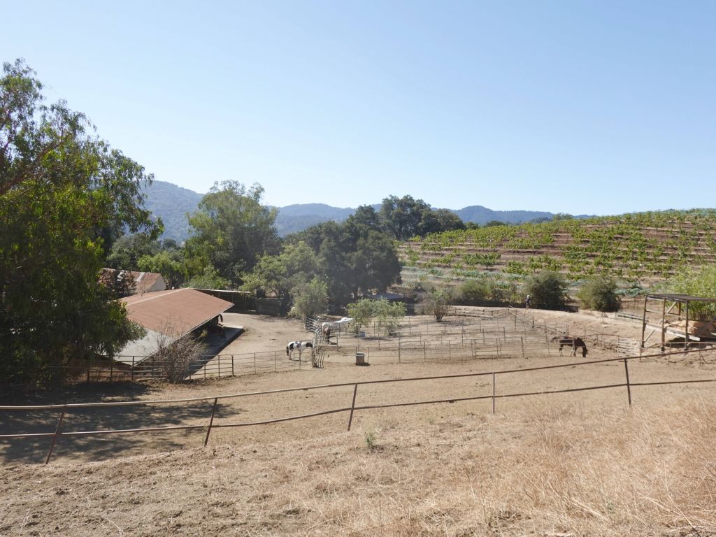
We've been going through bike/walks around the urban landscape next to our house. We found a hole in a fence at the end of our street, so we went to check it out, that took us to 280 and stevens creek. There was a big tunnel for the creek, but a second huge tunnel, for I don't know what, it's big enough for a road (advance planning, nice).


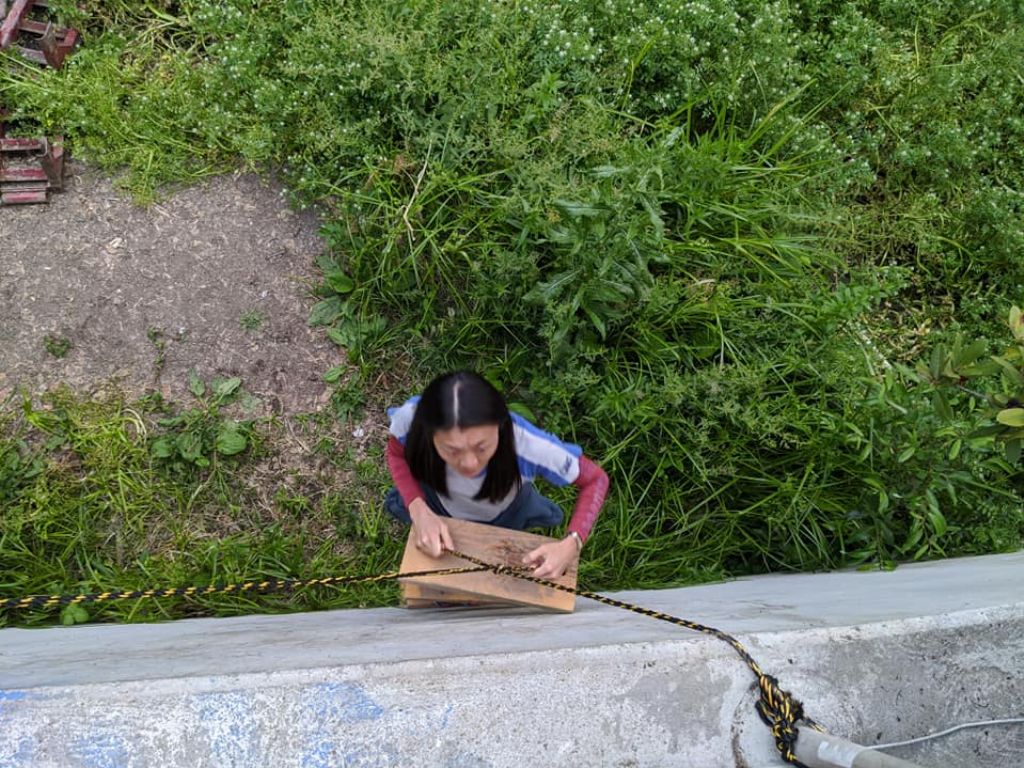
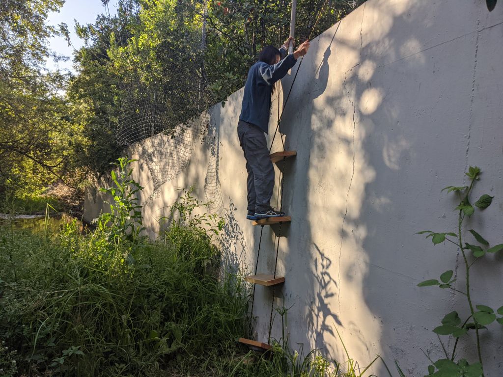
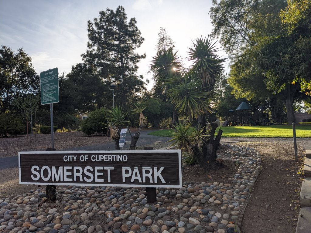
Many years back, when I jumped a fence to get there, I couldn't go down, but someone nicely installed a rope ladder recently, so we went down and into the tunnel. That took us to the railroad (mostly unused) on the other side and connected to a street, or to sommerset park after removing a few metal wires that tried to patch a hole in the fence (thank you swiss army knife).


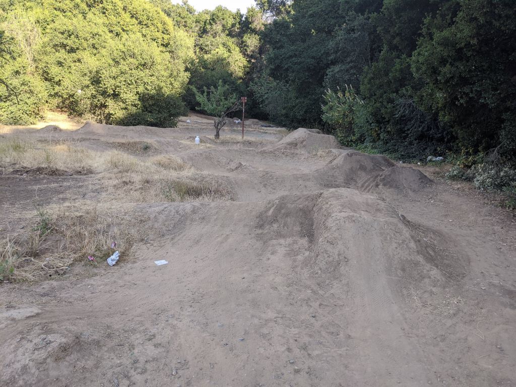
The secret BMX park is inaccessible unless you get to it through the railroad tracks from another access point. No idea who built it, it doesn't look official but yet it was well built: https://www.google.com/maps/@37.3322805,-122.0624639,157m/data=!3m1!1e3


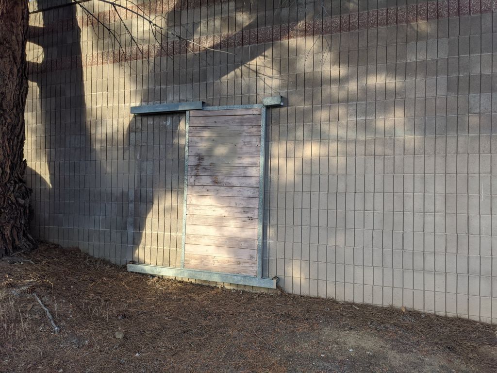
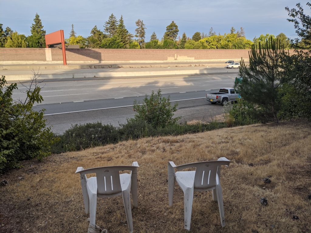
We found that the freeway had doors in the wall, some you could just open and someone put chairs on the other side, maybe to just relax and watch traffic go by? :)


On the way back, I noticed that you could drive from a hole between the freeway walls through a railroad crossing that had been built for car crossing, to nowhere, the road stops there, although it almost connects to the stevens creek tunnel.


There is probably some interesting history and roads that maybe used to connect and don't connect anymore, or were meant to connect, but never did in the end. Either way, it was fun, we felt like urban explorers :)

See more images for Urban Explorers
2020/05/22 45 mile loop to Alviso, Don Edwards Wildlife Refuge, and Back via the Green Belt
π 2020-05-22 01:01 in Exercising
A mere 13 years ago, when we still lived in Sunnyvale, we did the shorter bike ride to Alviso. The ride was 24 miles then.
It was time to go back, but now that we live farther, and that I extended the loop, it was 45 miles this time (the whole loop was about 7H of clock time and 5h of actual biking time, or longest for us this far). (click on the garmin recording for more stats and a bigger map)

nice pink house on the way to Steven Creek Trail

lovely tree
lovely tree


Norcal radar site
Norcal radar site


babies are grown up already

so proud
so proud


Eventually we got to Alviso, the land that time forgot:


prime real estate in a flood zone, awaits for you


interesting house
interesting house

it was a mixed neighborhood


From there, we got to the Alviso Don Edwards loop (we did the longer double loop):


for once, a train that almost looked fast


salt from evaporation


After the long loop, it was time to bike all the way home (almost 2H), back around great america, 49ers stadium, and greenbelt back to Stevens Creek Trail:


This was our longest bike ride ever, it went well considering. Maybe 50 miles next time? :)

2020/05/01 Finally did the Montebello to Back Mountain to PageMill Loop
π 2020-05-01 01:01 in Exercising
It's a loop I knew was possible after biking up Montebello some 10 years back, but going all the way to Pagemill seemed a bit daunting. Turns out, it wasn't and it's only a 25 mile loop, albeit with a 2600ft climb. (click on the garmin recording for more stats and a bigger map)

Here is the navigation track on google maps

Took about 25mn and 4 miles to get to the bottom of montebello (600ft altitude), and then we biked up. Jennifer did better on the way up than I did (last time, many years back, it was the other way around):

then up
then up


more up
more up

took about 1h from the bottom to get to ridge (4 miles, 1600ft climb)

welcome to the top before entering the preserve

not a terrible time for a 2000ft climb


new gogle campus
new gogle campus


top of black mountain

2h, 2500ft up to the top

the hiking path was nicer


we got to pagemill in no time

nice views from pagemill


I know this turn from driving up, can't clip the apex on this one :)

We then got back to foothill and biked home:


Very nice loop, glad that we did it.


More pages: March 2023 September 2022 February 2022 January 2022 October 2020 August 2020 May 2020 April 2020 February 2020 July 2015 February 2013 July 2012 February 2012 June 2011 May 2011 July 2010 April 2010 December 2009 November 2009 May 2009 April 2009 March 2009 September 2008 June 2008 May 2008 January 2008 October 2007 September 2007 June 2007 May 2007 April 2007 March 2007 February 2007 August 2006 July 2006 June 2006 March 2006 September 2004 August 2004 May 2004 April 2004 March 2004

Contact Email